DSNI’s Neighborhood by the Numbers
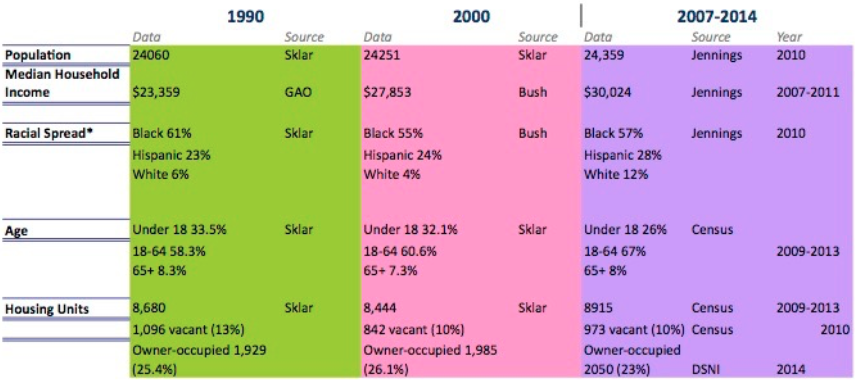
**Note on income: If you account for inflation, the value of the median income has actually fallen. In 1990 dollars, the 2000 figure would be $14,958, and the 2007-2014 income figure would be $16,124. (Calculated at www.saving.org/inflation/inflation.php.)
**Note on boundaries: Most of these data sources cover the area known as the Dudley Neighborhood (also the Dudley Village Campus under the Promise Initiative), which includes Dudley Square, Dudley Triangle, and Grove Hall, in addition to other small neighborhood areas. It is composed of US Census Tracts 801, 803, 818, 902, 903, 904, 906, 913, and 914. While Sklar does not specify the exact census tracts covered by her data, the numbers are consistent with other sources and probably cover a similar if not identical area. Most of DSNI’s work has focused on a smaller area within that neighborhood.
Bush = Bush, James Michael. “Community Driven Economic Development Strategies for Rainier Beach.” MPA Thesis. University of Washington, 2010.
Census = Direct tabulations by NHI.
GAO = United States General Accounting Office. (1995). Community Development: Comprehensive approaches address multiple needs but are challenging to implement. GAO/RCED/HEHS-95-69. Government Printing Office.
Jennings = Jennings, James. “Select Profile of Poverty—Dudley Village Campus, Dudley Square, Dudley Triangle, and Grove Hall: Boston, Massachusetts.” Research Brief. Tufts University, April 2014. (Same geographic area as Census, above.)
Sklar = Sklar, Holly. “Dudley Street Neighborhood Initiative: Building on Success, 1984-2002,” July 10, 2002.
* Totals do not add up due to significant but inconsistently tabulated “other” populations, primarily Cape Verdean, and the Census inconsistency about tabulating Hispanic identity separately.